Annapurna Circuit with Tilicho Lake Trek - 20 Days

Based on 1 Review
Annapurna Circuit with Tilicho Lake Trek
Trip Details
  • Destination: Nepal
  • Trip Difficulty: Challenging
  • Trip Style: Trekking
  • Transport: Tourist/local bus & private car
  • Food: Breakfast,Lunch and Dinner
  • Accommodation: Hotel, lodge (tea house)
  • Group Size: 01 to 15 pax
  • Max Elevation: 5415 meters, Thorong - La pass, stunning views
  • Approx. walking: 6-7 hours
  • Starts in: Kathmandu
  • Ends in: Kathmandu
  • Best Season: March to May, September to December are the best month.

Highlights

  • Crossing Thorong La Pass (5,416m), the widest pass in the world
  • Visiting the highest lake in the world, Tilicho Lake (4,910m)
  • Breathtaking views of the Annapurna mountain range
  • Dipping at the hot water springs of Tatopani
  • Spectacular lakes, glaciers, gorges, and waterfalls along the way
  • Pilgrimage to Muktinath, a sacred temple for both Hindus and Buddhists devotees
  • Gorgeous sunrise on the backdrop of the snow-capped mountains from Poon hill
  • Incredible hospitality of the local people
  • Cultural and religious exploration of the charming villages of the region

About Annapurna Circuit with Tilicho Lake Trek

The classic Annapurna circuit trek with Tilicho lake is one of the most popular treks in Nepal. The trail moves along the Annapurna region exploring the geographical diversity and the cultural heritage of the Annapurna region.

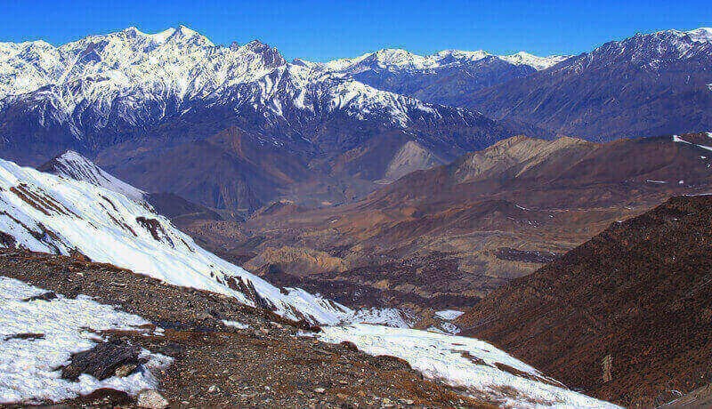
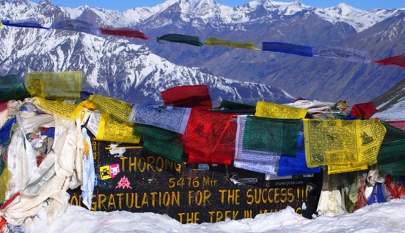
The special package of “Annapurna Circuit Trek with Tilicho Lake - 21 Days Itinerary” provides exciting trekking experience of the Annapurna region along with the chance to visit the mesmerizing Tilicho lake. The trek follows the Marsyangdi valley to the north of the Himalayan range of mountains. It crosses the Thorong La pass (5416m) to descend into the desert-like landscape of upper Kali Gandaki valley.

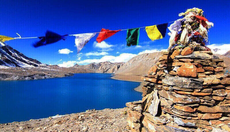
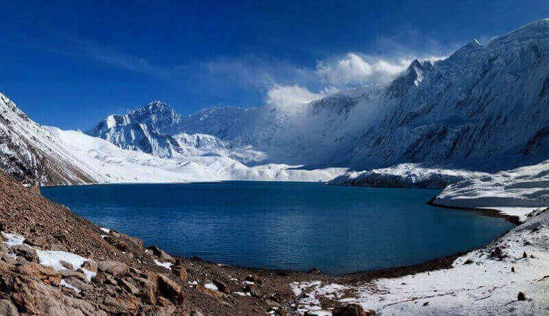
The route passes through charming Gurung, Manangis, and Thakali villages. The breathtaking views of the 7000m plus mountains of the Annapurna region will amaze you. You will stay in some of the best trekking lodges and guesthouses.  The visit to the highest lake in the world, Tilicho lake is the main highlight of the trek. The side trips form the Jomsom, Muktinath, and Manang are also the major attractions of this trek.

You will need to acclimatize at regular intervals and take it slow while trekking in these high altitude Himalayan regions. We descend into the Kali Gandaki gorge, the deepest gorge on the planet, and visit the sapphire lake of Tilicho (4950m) which is the highest located lake in the world. The sapphire lake of Tilicho lake has an emerald glow. We pass through the Thorong la pass which is the widest mountain pass in the world.

The trek ranges from subtropical woodlands to dry, arid landscapes. We pay a visit to the spiritual hub of the region Muktinath and enjoy the amazing sights of the Annapurna range from the popular vantage point of poon hill. This 21 days Annapurna circuit Tilicho lake itinerary is one of the most satisfying and rewarding treks in the Annapurna region. Our professional guides will accompany you along the journey to ensure your trek is safe and pleasant. 

So what are you waiting for? Come and experience the Annapurna region and its pure beauty. We are offering you this special trek package at a reasonable cost. Hurry up! Book your trip now.

Best Time for Annapurna Circuit Trek with Tilicho Lake
The Annapurna circuit trek via Tilicho lake is possible throughout the year. However, there are risk factors involved like freezing weather and avalanches during winters and monsoons. Thus, the best season considering the weather and other external factors are the spring and the autumn season.

Spring (March-May)

The trekking season begins in March. Spring season brings a glorious display of rhododendron forests along the trail. The weather is stable and the trail becomes pleasant with wildflowers blooming all around. Spectacular views of the snow-capped mountains on the backdrop of clear blue sky welcome us.

Autumn (October-November)

The autumn season is the peak season for trekking and travel in Nepal. This season is a favorite among the trekkers because of the favorable weather and soothing climate. The monsoons clouds disappear and the skies are bright and clear. You will get a spectacular view of the mountains.

The temperature is ideal for trekking. Days are warm and can reach up to 20 degrees Celsius in high altitudes. Nights are cold with dipping to 5 degrees Celsius. The most prominent festivals, like Dashain and Tihar, also fall during this period. Autumn is the busiest season, and the lodges and guest house get packed quite soon. Book early to be safe from any inconvenience.


The Difficulty Level of The Annapurna Circuit Trek with Tilicho Lake
The difficulty level of Annapurna circuit trek with Tilicho Lake is quite strenuous and challenging. The hiking ranges from 6-7 hours on average for more than two weeks at high altitude.

Acclimatization at regular intervals and slow ascent minimize the risk of high altitude sickness. The routes include steep climbs and deep descents. You will pass through alpine forests, passes, glacial lakes, deep gorges, base camps, and others.

The trek is not technical, but the trekking can get strenuous and physically taxing at times. Prior hiking experience with good physical fitness and stamina is a plus. Exercise regime and jogging training two weeks ahead of the trek is a must. Trekkers should mention their pre-existing conditions if any to the team in advance.

Itinerary

Expand All Hide All

Upon arrival at the airport, our staff will greet you at the airport and help you check in at the hotel. You can stroll around the streets of Thamel in Kathmandu or prepare for the trek. You will stay overnight at the hotel. 

  • Accommodation: Madhuban Hotel
  • Place: Kathmandu
  • Altitude: 1400m

We drive from Kathmandu to Bhulbhule on a public bus. The scenic drive overlooking the beautiful green hills and the rivers will take almost 7-8 hours. We will stay overnight at Bhulbhule.

  • Meals: B/L/D
  • Accommodation: Lodge
  • Place: Bhubule
  • Altitude: 923m

After early morning breakfast at Bhulbhule, we begin our trek to the village of Chamje. We will trek through the steep and slippery trail with paddy fields along the way. After having lunch at Chamje, we will hike through the rhododendron forests until we arrive at Chamje. We will spend the night at Chamje.

  • Meals: B/L/D
  • Accommodation: Lodge
  • Place: Chamje
  • Altitude: 2200m

We begin our trek from Chamje early in the morning. We cross a suspension bridge over the rushing Marshyangdi river. After some time we will arrive in the village of Tal. A stunning waterfall and many mani walls with sacred words of Om Mani Padme Hum welcome you in Tal.

We resume our trek to Dharapani after lunch. The grassy trail through bamboo and sugarcane fields leads us to the Dharapani in the afternoon. An exceptional meal awaits us at Dharapani. We will spend the night at the guest house in Dharapani.

  • Meals: B/L/D
  • Accommodation: Lodge
  • Place: Dharapani
  • Altitude: 1406m

The trail on route to Chame consists of a steep forested ridge. The trail climbs steeply from Danaque to Timang at the junction of Nar- Phu valley. You will see several landslides sites along the way.

The gorgeous sight of snow-capped Mountains, including the Lamjung Himal, Annapurna II, and Annapurna IV welcomes us. There are hot springs in the route that can help relax and loosen up during the trek. We will stay overnight at Chame.

  • Meals: B/L/D
  • Accommodation: Lodge
  • Place: Chame
  • Altitude: 2710m

The trail along a steep and narrow valley lets you have a sneak peek of the Paungda Danda rock face. Paungda Danda rock face is a dramatic curved rock face with a height of 1500 m from the river below.

We have a spectacular view of the Annapurna 2 to the south and Pisang Peak to the northeast. After a few moments of rest and overlooking the breathtaking scenery, we make our way back to the Manang valley floor enjoying the captivating landscape. We stay overnight in Pisang.

  • Meals: B/L/D
  • Accommodation: Lodge
  • Place: Pisang
  • Altitude: 3300m

We resume our trek through the upper part of the Manang district. The terrain is dry and heavy as this part of the region is cut off from the Annapurna range. The local people are yak herders and grow crops only for a specific part of the year. The exclusive trading right allows them to trade freely with the people from the Tibet region.

There are two alternate trails north and south of the Marshyangdi river that joins in Mungji. The southern route by the Hongdae airstrip (3,325m) is short and less challenging. However, the northern route via Ghyaru that follows the north bank of the river offers better views of the region. The course provides outstanding views of Mt. Annapurna, Pisang Peak, and others.

From Mungji the trail then continues passes through the hidden village of Bryanga (3,475m) to arrive at the famous village of Manang(3,500m). As we arrive in Manang, the weather becomes more cold and dry. A short visit to Barge Monastery, the biggest monastery in the Manang District will liven up your spirits. We stay overnight at the guesthouse in Manang.

  • Meals: B/L/D
  • Accommodation: Lodge
  • Place: Manang
  • Altitude: 3519m

We acclimatize at Manang village on day eight. It allows our bodies to adapt to the changing high altitude. We do not stay idle even on acclimatization day and hike for a short time to either Bhojo gumba or Gangapurna lake.

You can also walk to the Braga village where there is a trekkers post run by Himalayan Rescue Association. The volunteer doctors will medicate and inform us about acute mountain sickness. We stay overnight in the guesthouse in Manang. 

  • Meals: B/L/D
  • Accommodation: Lodge
  • Place: Manang
  • Altitude: 3519m

After acclimatizing for a day in Manang, we head out for the western gates and follow the path down the river. We cross the river and make our way through the coniferous forests in the southern sides.

After reaching the village of Kangsar, we trek up towards the Siri Kharka passing a monastery along the way. The spectacular view of the Gungang Himal and Mt. Chulu on the backdrop keeps us motivated in the steep uphill walk. We stay overnight in the Siri Kharka.

  • Meals: B/L/D
  • Accommodation: Lodge
  • Place: Siri Kharka
  • Altitude: 4060m

The trek from Siri Kharka to Tilicho base camp moves along narrow paths in loose scree and landslide areas. The track isn't particularly steep or strenuous, but the narrow pathways make the journey quite taxing. The trail goes along the center of the landslide area overlooking the impressive rock formations. We will stay overnight at the Tilicho base camp.

  • Meals: 4140m
  • Accommodation: Lodge
  • Place: Tilicho Base camp
  • Altitude: 4040m

We will trek early through robust, steep, and switchbacked ascent. The trail then gradually inclines to the side of the mountain before reaching watershed. You can spot yaks and deer grazing along the trail. After a trek of a few hours, we reach the Tilicho lake.

Tilicho is a sapphire lake nestled at the foot of the north face of the Tilicho peak. The spectacular Tilicho lake is the highest lake in the world. The lake is also a sacred site for Hindu pilgrims as the lake features in the holiest text the Ramayana. The French expedition team termed it as the "great ice lake." We return to Siri Kharka, where we stay overnight.

  • Meals: B/L/D
  • Accommodation: Lodge
  • Place: Siri Kharka
  • Altitude: 4060m

From Siri Kharka we descend towards the Khangsar village. We pass through Tare Gumba, which is a Thousand-year-old monastery. The local people highly revere the monastery.

The uninhabited village of Khangsar has occasional herders during festivals. The trail consists of a rock wall from Kangsar. We trek furthermore until we reach a seasonal bridge in the Thorong Khola valley. We cross the river and climb for a while to reach the plateau. After walking further for some distance, we reach Yak Kharka. We spend the night in Yak Kharka.

  • Meals: b/l/D
  • Accommodation: Lodge
  • Place: Yak Kharka
  • Altitude: 4040m

The trail is an uphill walk from Thorong Phedi. After crossing a suspension bridge, we reach Ledar village. We gradually climb some distance as we pass through towering cliffs to arrive at the Thorong Phedi.

The Thorong Phedi is a last settlement before the Thorong la pass. Excellent views of Mt Gundang, Mt Syagang, Thorong peak, and Mt Khatungkan. We stay the night at the Thorong Phedi.

  • Meals: b/L/D
  • Accommodation: Lodge
  • Place: Thorong Phedi
  • Altitude: 4600m

The Thorong La Pass is one of the highest mountain passes in the world. The trail ranges from Thorong Phedi to Muktinath. We will get up early in the morning to ascend the Thorong La Pass.

The route is challenging and physically taxing, but the view from the top compensates it. The panoramic view of the Muktinath valley will overwhelm you. We click as many pictures as we can and descend back to the Muktinath valley. We spend the night at a guesthouse in Muktinath.

  • Meals: B/L/D
  • Accommodation: Lodge
  • Place: Muktinath
  • Altitude: 3800m

An early morning pilgrimage to the Muktinath temple will awaken you spiritually. The Muktinath temple is a holy site for both Buddhists and Hindus. Every year thousands of tourists make a pilgrimage tour of the Muktinath temple. There are 108 stone taps constructed of a cow's head and two small ponds in the premises of the temple. Devotees believe that if you take a bath under the 108 sacred stone taps and dip in the lake, you will be free from all the sins from your past life.

A short walk commences from Muktinath passing through a collection of Chortens is the Dhola Mebar Gomba or the Jwalamai (goddess of fire) temple. Where a holy flame of natural gas burns behind a grill just above the spring all the time, we will then return to the guest house to have our breakfast. We will then resume our trek through the Jharkot village.

The Jharkot village is one of the windiest villages in the Jomsom area. Strong winds sweep the terrain all around the year. We then resume our trek to Kagbeni. Kagbeni is a small village known as the gateway to the upper Mustang region. We will trek downhill to the famous village of Jomsom. There are many guest houses and lodges in Jomsom. We will spend the night at a guesthouse in Jomsom.

  • Meals: B/L/D
  • Accommodation: Lodge
  • Place: Jomsom
  • Altitude: 2750m

We drive from Jomsom to Tatopani on a bus. The scenic drive overlooks the snow-capped mountains and the green hills. After a journey of 5-6 hours, we reach the Tatopani village.

Tatopani has a lot of natural hot springs. You can relax at the hot water springs and loosen up. The hot springs contain medicinal properties as per the locals. We stay overnight at a guest house in Tatopani. 

  • Meals: B/L/D
  • Accommodation: Guest House
  • Place: Tatopani
  • Altitude: 1290m

The trail leaves Kali Gandaki and moves toward the Ghar Khola valley. We pass through the terraced farmlands overlooking the snow-capped mountains all around.

After passing the villages of Shikha and Chitre, we reach a forest full of rhododendron trees. The forest turns pink and red. After walking for almost 7- 8 hours, we reach the Ghorepani village located at the ridge top. We stay overnight in Ghorepani.

  • Meals: B/L/D
  • Accommodation: Lodge
  • Place: ghorepani
  • Altitude: 2750m

Poon Hill is the best viewpoint to enjoy the good morning sunrise over the snowy peaks. Early in the morning, we hike to Poon Hill and enjoy the spectacular moment, taking photographs. Then we trek down to Ghorepani, have a breakfast and trek down all the way to Nayapul via Ulleri and Tikhedhunga. Then we catch a taxi to Pokhara and transfer to the hotel. Overnight at hotel. 

  • Accommodation: Hotel
  • Place: Pokhara
  • Altitude: 827m

We will drive through the scenic Prithvi highway to Kathmandu from Pokhara. The drive is 6-7 hours long and overlooks the scenic beauty of the hills in the region. We will spend the night in Kathmandu hotel.

  • Accommodation: Madhuban Hotel
  • Place: Kathmandu
  • Altitude: 1400m

Our staff will pick you up from the hotel and transfer you to the Airport. You can then board a flight to your desired destination.

    Cost Details

    • Airport pick up & drop off transport
    • 2 night standard twin sharing hotel in Kathmandu with breakfast.
    • 1 night standard twin sharing hotel in Pokhara with breakfast.
    • Public bus transportations from Kathmandu to Bulbule and tourist from Pokhara to Kathmandu
    • Shared jeep/Bus from Jomsom to Tatopani and private transport from Nayapul to Pokhara
    • All standard meals like Breakfast / Lunch / Dinner, during the trek with a cup of tea or coffee during breakfast time.
    • Tea house accommodation during the trek.
    • Gov. Licensed experienced helpful and friendly guide and porters (1 porter for 2 people) and their food, accommodation, salary, equipment, and accidental insurance for all staff.
    • Annapurna Conservation Park Permits fee.
    • TIMS Fee- Trekkers' Information Management System
    • Down Jacket and sleeping bag (if needed)
    • First aid box with normal medical supplies, including Oximeter and pulse meter checker. First aid
    • Trekking map
    • Government taxes & office service charge
    • International flights
    • Nepal entry visa fee
    • Your travel and medical insurance (recommended)
    • Personal expenses (phone call, internet, laundry, bar bills, snacks, battery recharge, bottled or boiled water, hot showers, porter for single trekker etc.)
    • Tips for trekking staff (tipping is expected)

    Client Reviews